This post is a redeterminaition of the map I found back in September of 2023.
I have been constantly researching the Twelve Mile Square and all of the maps and surveys associated with it in my spare time ever since I discovered the map I wrote about back in November of 2023. I’ll be the first to admint that we are all human and we all make mistakes, overlook something or miss something that’s important. If we didn’t make mistakes and knew everything there is to know, we wouldn’t learn anything new and we as a species would be a pretty boring bunch. Well, I’m owning this one because what I missed in my research has now added more depth and more meaning to the history of the map I discovered. What I had missed was that the actual scanned file of the original 1816 map of the Twelve Mile Square is on the BLM website, microfilmed in 1961. As soon as I saw it, I immediately knew that the map I had discovered was just a copy. I only felt a twinge of disappointment for a second because the map I was looking at was the original.
When I made the original discovery, I had reached out to the Bureau of Land Management to see what they thought or what they had in their collection, but I did not receive a reply back. In contacting the Deputy Director of the Northeastern States District of the Bureau of Land Management this past week, he forwarded my inquiry to the Director of GLO research and response. I was then contacted by Anne Dement, a Land Records Specialist from the BLM. I found out then that the map I discovered was drawn in 1904 based on the certification note attached to it. The interesting thing is that the 1904 map was copied by hand directly from the original 1816 map. That is why the notes on the 1904 map are exact duplicates of the ones found on the original. It was a common practice for all notes of significant events and policy changes affecting the administration of land transactions in the areas that were on any original map, were copied over to copies being made to ensure all information was passed on throughout records and maps. The original 1816 map is housed in the Cartographic Collection of the National Archives in College Park, MD. This new information is courtesy of Anne Dement, Land Records Specialist, General Land Office, BLM Eastern States, Falls Church, VA.
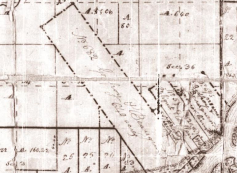
Here is the original 1816 map downloaded from the BLM website:
Here are some great clues that tell us that the 1904 map I discovered was drawn directly from the original. First, when we look at the river tract that belonged to Godfroy & Beaugrand on the original map, there is a major crease with parts of the map that are missing. You’ll notice that the “d” is missing from Godfroy’s name:
On the 1904 map, the same tract was copied verbatum as there is no “d” in Godfroy’s name:

The second clue I saw on the original was the tract owned by Whitmore Knaggs has a crease at the end of his first name, which made it look like Whitman rather than Whitmore:
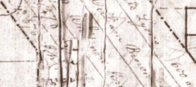
When the name was copied to the 1904 map, it was read and copied as Whitman:

Here is the colorized version of the original 1816 map provided by Anne Dement:
As I said before, I am not shrinking away from this whole experience simply because I missed something. I have learned a great deal from this experience and I wanted to pass on this “lesson learned” to you so that any research you do in the future, you may not make the same mistake I did.
The good news is this…the Lucas County Engineer’s Office is in the possession of a120 year old map that is a part of the history of the Twelve Mile Square and in it’s own right original to its purpose. Also, the Bureau of Land Management is now in possession of a digital copy of the 1904 map I discovered and have added it to their database for future reference, as Anne Dement indicated that they were glad to add it to their collection since the copy of the 1904 map is in much better condition than that of the 1816 map.
One more item I wanted to share is this. I took a copy of our digital 1904 map and superimposed a portion of the 1816 map over it to make the map whole again for those of you that indicated a desire to see it this way:
Just as in genealogy, researching history can be tricky and it is up to us to completely uncover the truth of historic events or items such as the map I discovered. In doing so, future generations will then be the benificiaries of our work. Remember, history is there for us to discover as it always has been. We just have to roll up our sleeves to uncover the facts and the truth. Let’s keep digging!
Sources:
The Bureau of Land Management
Acknowledgements:
Shannon McCrory, Deputy Director Manager, Bureau of Land Management, Northeastern States District
Anne Dement, Land Records Specialist, General Land Office, BLM Eastern States, Falls Church, VA
Special Thanks:
My wife for her constant love and support
Brian
