In my last post, I wrote about a map I discovered from 1816 and discussed the history surrounding the map, specifically relating to the University of Michigan, John M. Moore, the Chief Clerk of the General Land Office and Major William Oliver. You can see my previous post, “The Discovery of a Lifetime” here.
I realized there was more to discover on the map with the names that were written inside some of the tracts that were a part of what was known at the time as “The 12 mile square at the foot of the rapids of the Miami of Lake Erie” and a special tract just west of the City of Perrysburg. Here are the men that I’ve uncovered that have added to the history of the map I discovered and our burgeoning country during the War of 1812 and and the years afterwards. I have added the tract numbers from the map in either parathenesis at the end of each man’s narrative or as part of their narrative below.
——————————————————————————————————————–
Col. Gabriel Godfroy (1758-1832) – established a trading post with business partner Jean Baptiste Beaugrand in Monroe Co., MI. and established a store on the Miami Rapids. Appointed sub-agent for Indian Affairs and activated with the 1st Regiment of the Michigan Militia and assisted Capt. Robert Lucas (Lucas County was named for Robert Lucas), War of 1812 (No. 682) & (No. 595-not confirmed).
——————————————————————————————————————–
Maj. Jean Baptiste Beaugrand (1768-1826) – Business partner with Gabriel Godfroy, as mentioned above, was in the Michigan Militia, War of 1812. Accused of killing a Kentucky volunteer, was found guilty of murder, but acquitted by reason of being possessed by the devil (No. 682) & (No. 595-not confirmed).
——————————————————————————————————————–
John Askins, Sr. (1739-1815) – Indian trader, merchant and was involved with the peace treaty at Greenville in 1795 as well as his son, John Askins, Jr. There is a street in the city of Maumee named Askins St. that falls within the tract that was owned by John Askins, Sr. (No. 577).
——————————————————————————————————————–
Samuel Ewings (1782-1822) – Samuel was killed by John Lewis, 9 Mar 1822 in Wood County, Ohio, probably the 1st murder in the county. John Lewis escaped from a small Maumee jail and was never heard from again. (No. 578).
——————————————————————————————————————–
Capt. Whitemore (Whitman) Knaggs (1763-1827) – Indian agent, fought with Gen. Anthony Wayne at the Battle of Fallen Timbers. A personal friend of Tecumseh. Present at the Surrender of Detroit and taken prisoner by the British and later released during the War of 1812 (No. 579).
——————————————————————————————————————–
Dr. William Brown – provided medical services to the Chippewa Indians for 20 years, thus the Chippewa requested of Congress that land be granted to Dr. Brown at the foot of the rapids of the Miami River, in the year 1817 (No. 580).
——————————————————————————————————————–
Archibald Lyons (1783-1837) – Indian trader and trapper, married a half French and half Indian woman with whom he had one daughter, Elizabeth (Mokitchenoqua). At the Treaty of Saginaw, a piece of land was set aside for her, out of which grew a chancery court suit. Archibald Lyons supposedly drowned in 1837 near Bay City, MI. (No. 581).
——————————————————————————————————————–
Francois Valliquet (d. 1817) – a Canadian, claimed land along with Amable Bellair by notice to the Land Office at Detroit, approved 25 April, 1808. Francois (Francis) Valliquet’s will was probated 26 Aug 1817 in Monroe, MI (No. 593).
——————————————————————————————————————–
Pvt. Amable Bellair (d. 1821) – a Canadian, claimed land along with Francois Valliquet as mentioned above. He was a private in the 2nd Reg., (Anderson’s) Michigan Militia. Amable Bellair’s will was probated 4 Dec, 1821 in Wayne, MI (No. 593).
——————————————————————————————————————-
Francis Deforges (b. abt. 1780) – not mentioned on the map, but records show he purchased a 2 acre tract, No. 594 that was surrounded by tract No. 593. Francis Deforges was declared insane and a person of an unsound mind by a jury of his peers in Detroit. I found no other mention made of Francis beside the records that show his purchase of tract No. 594.
——————————————————————————————————————–
Maj. Amos Spafford (1753-1818) – Surveyor, collector, & postmaster was born in CT, served at the Battle of Fort Meigs under William Henry Harrison. Amos named the cities of Cleveland and Perrysburg. He also traveled to Washington, D.C. twice to petition the U. S. government on behalf of himself and other men on this map to have their lands returned to them by right of pre-emption* after the War of 1812. Amos Spafford and family members are buried at the Ft. Meigs cemetery (Spafford’s tract is between tracts No. 64 & No. 65 as mentioned on his Historical Marker).
——————————————————————————————————————–
Tract No. 597 – St. Michael’s, 60 Acres (not confirmed). I did not find any other information regarding St. Michael’s.
——————————————————————————————————————–
*The Right of Pre-emption, a contractual right to acquire certain property newly coming into existence before it can be offered to any other person or entity, became a House of Representatives bill, H.R. No. 91:
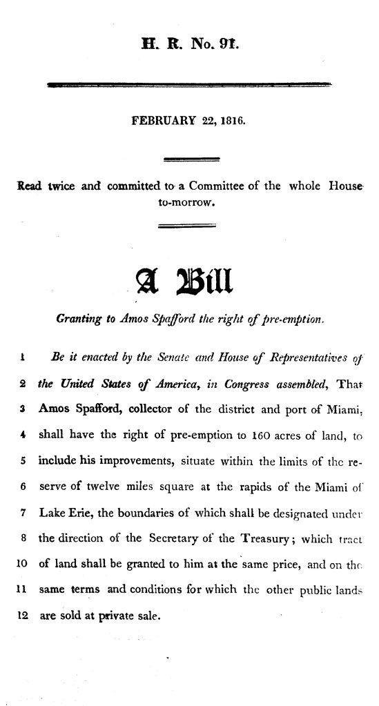
Courtesy of the Library of Congress
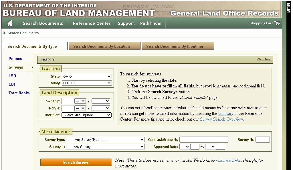
After all this research and discovering so much about Amos Spafford and the other men adding to the history of the map I discovered, I was still wondering why I didn’t find any documents pertaining to the 12 mile square on the website of the Bureau of Land Management. Perhaps I was missing something by using their search tools, so I approached it from a different angle. I did an internet search using the quotation mark operators around the words 12 mile square in my search and I wasn’t disappointed.
I found this on the BLM website:
This document, as is the Dec. 1816 original map that I found, is based on the 1805 survey done by Deputy Surveyor, Elias Glover. This sketch was created for the sole purpose of aiding Amos Spafford, as directed in House Bill H.R. No. 91. If you read in the lower right corner of the map, you will see an approval note dated 26 June, 1816, approving the tract for Amos. It is initalized A.J.D. – Alexander J. Dallas, Secretary of the Treasury and Interim Secretary of State. The tracts on this map match exactly the tracts on the map I discovered.
All I have to say about this entire experience is this…never underestimate the history behind any item you find. If there are clues on or in whatever you may have discovered, dig deep to see what you can find out about it. You never know what you may discover!
Nov. 25, 2023 Update
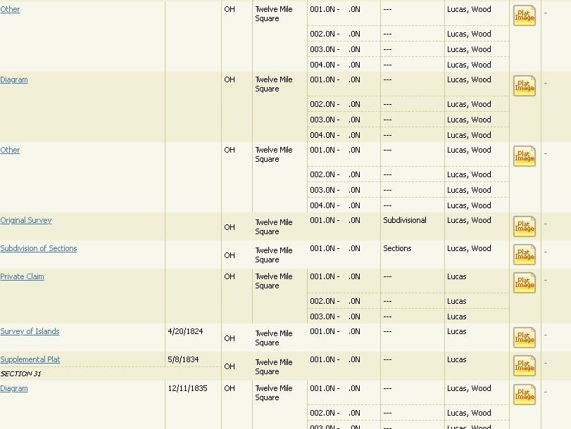
I decided to go back to the BLM (Bureau of Land Management) website and take another crack at finding more documents about the 12 mile square reserve. This time I really looked through every single item I could and decided not to use any date ranges as search criteria. I simply used State: Ohio, County: Lucas and Meridian: Twelve Mile Square:
Jackpot!
With the exception of the map of 1816 I found, everything the BLM has had in their possesion has been scanned, including the Original 1805 Survey by Elias Glover:
Here is the link to the results…BLM Twelve Mile Square.
Just as in genealogy, searching for history is a never ending venture. I’ve been called a “dog with a bone”…and that’s exactly what I am. I can’t give up on something until I can at least find clues to what I am looking for or the prize itself.
Sources:
Reminiscenes of Pioneer Days in Wood County and the Maumee Valley, Charles W. Evers (1837-1909)
University of Oklahoma College of Law Digital Commons – America Indian and Alaskan Native Documents in the Congressional Serial Set: 1817-1899 – James W. Knaggs, Administrator of Whitemore Knaggs – 12/18/1860
The Storekeepers Project #8: J-B Beaugrand and Sans Souci – Pat Tucker for The Storykeepers Project – 13 Aug., 2013
Welcome to Hard Times: Two French Merchants and Militiamen in the Detroit River Region During the War of 1812 – Patrick M. Tucker and Laurel E. Heyman, 2012
The Saginaw Treaty of 1819 Between General Lewis Cass and the Chippewa Indians – Written in Celebration of the Treaty, September 19, 1919 – Fred Dustin
Ewing Family Journal – Vol. 17, No. 2 – Ewing Family Association – May 2011
The Maumee Valley – How to Recognize Its History Woman’s Part in Pioneer Home Life – Members of the Maumee Valley Pioneer Association – 1895 – The Andrew-Jones Printing Co., Toledo, Ohio
The Publications of the Champlain Society – Champlain Society – 1920 – Original from the University of Michigan
Flint Michigan History and Early North American – Alan Teelander – 9 Aug., 2012
The Library of Congress
The Bureau of Land Management
Ancestry©
Special Thanks
Patrick M. Tucker (1951-2022) – born in Toledo, OH, served in the U.S. Army as Lt. Col., and was a Professor of Archeology at the University of Toledo – author of historical and archeological publications dating from 1979 – 2014, which included research publications of the Spafford homestead.
Gary L. Franks – Ohio author, graduate of the University of Toledo – Bachelor of Science Degree in Mechanical Engineering – registered PE in 14 states – worked at SSOE, Inc., Owens-Illinois, Union Carbide, Boeing and General Mills. Honored with the Bentley Award in 2016 by Historic Perrysburg, Inc. – A member of the Ohio Historical Society, Historic Perrysburg, Inc., Museum of the Great Lakes, Wood County (OH) Genealogical Society and is a founding member of the Perrysburg Area Historical Museum. Thank you Gary for your experience and mentorship!
Long time friend, Matt Lewandowski
Thank you to all of my readers! I so appreciate your readership, responses and input!
My wife, Cheryl for your love and support.
Happy Thanksgiving to all family and friends!
Brian
