I have worked for the Lucas County Engineer’s Office in Ohio for almost 25 years and have been the Records Manager for about 10 of those years. I have never seen a survey plat map or any other type of map for that matter more intriguing or surprising than that of the Dec. 1816 general plat map I discovered buried in a group of 1960’s township maps I was in the process of archiving.
A note in the lower left hand corner of the map states “GENERAL PLAT of the Tract twelve miles square at the foot of the rapids of the Miami River of Lake Erie ceeded by the Indians to the Unites States by the Treaty of Greenville Aug. 3rd 1795 – Drawn from a scale of 60 chains to an inch Dec. 1816“.

Reeling from this discovery, I wanted to know more about this map and in doing some research, I found the following excerpt.
An excerpt from a book called “A Story of Early Toledo” by John H. Doyle © 1919 states “…by special act of Congress, at the session of 1816-1817, this twelve miles square reserve at the foot of the rapids at the Miami of Lake Erie was ordered surveyed and sold. The tract was surveyed and divided into several tracts numbered from one up. River tracts one and two are interesting here. A company of men, including William Oliver, Martin Baum, Jacob Burnet, William C. Schenck, John Piatt, Robert Piatt, William N. Worthington and others, purchased at the sale of these two tracts, with others, from the government at $76.06 per acre on terms requiring one fourth down and the balance in three equal annual payments, and these gentlemen, before making any but the down payment, adopted a plat, with streets and town lots, and called it Port Lawrence, and immediately offered these lots for sale at an auction to be held September 17, 1817, at Fort Meigs…”
The William Oliver mentioned above fought in the War of 1812 at the Battle of Fort Meigs under William Henry Harrison, future President and also began the building of a hotel in Toledo now known as The Oliver House. William Oliver also laid out the towns of Maumee, Port Lawrence and Vistula. Port Lawrence and Vistula would become the City of Toledo. Major William G. Oliver (1767-1851), later relocated to Cincinnati, Ohio. When William Henry Harrison became president, he appointed William Oliver as Postmaster of Cincinnati. William Oliver passed away in 1851 in Cincinnati and is buried at the Spring Grove Cemetery. Coincidently, my ancestral cousin, Jesse Timanus, a Hamilton County Commissioner and his wife are buried at the Spring Grove Cemetery.
Now getting back to the map, there were other notes that were written on the map that have quite a historical value. First, there are tracts of lands highlighted in red on the map and a legend at the bottom of the map, the legend stating “Denotes Lands Selected for the University of Michigan“.
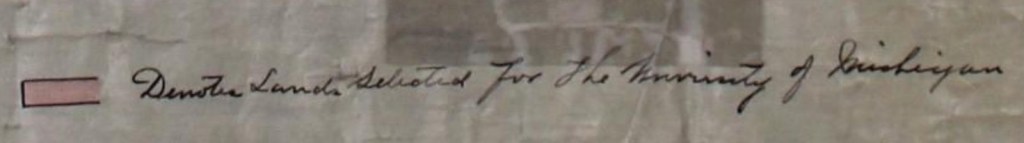
It’s possible that this means this could be one of the earliest documents to state the name of the University of Michigan. The tracts of land highlighted were obtained by Congress for the aid to the University, but were later purchased by William Oliver and his associates.
You can read more about the history here. Page 205-207.
Another note hand written in red in the lower right corner states the following:
“Instructions were issued on 21 Aug. 1821, that the lands above represented (not being town lots, but lots) may be relinquished under the Act of 2d Mar 1821. Subdivisions of original tracts are however, inadmissible. The lands alluded to are those not bounded by Sectional lines. See letter to the Register at Woo 21 Aug. 1821. J.M.M“
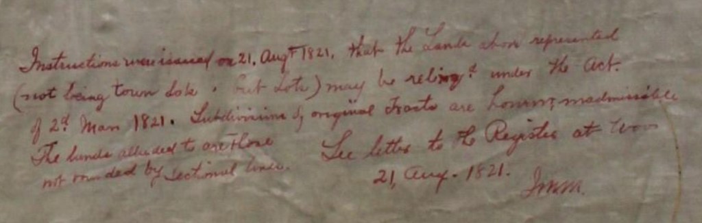
The end part of this note states “See letter to the Register at Woo“. It’s almost certainly a reference to the General Land Office at Wooster, Ohio. A presidential proclamation of 25 Feb. 1815 by President James Madison and Josiah Meigs, Commissioner of the General Land Office states the land office was to be moved from Canton, Ohio to Wooster, Ohio:
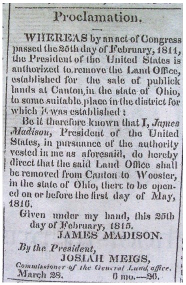
Courtesy of Wikipedia (from The Repository-Canton, Ohio)
The last of the note above is initialed JMM.
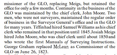
After doing some more research, it turns out that JMM is John Massey Moore (1795-1861). John M. Moore was appointed Chief Clerk of the General Land Office by Josiah Meigs.

Courtesy of the Bureau of Land Management
Here is the map I discovered. There is a certification letter attached to the side of the map from the Department of Interior, General Land Office, dated 8 April 1904, certifying the tract:
This discovery is a once in a lifetime discovery and I feel proud and humbled to be the one that will now play a part in this maps’ conservancy and secured history for future generations to come.
Acknowledgements:
Brian Williams, Assitant Director and Archivist for University History-Bentley Historical Library at the University of Michigan
Connie Conners, Ohio History Connection
Pari J. Swift, University Records Manager, The Ohio State University
Jason Alexander, Central Services Division Manager, Hamilton County Clerk of Courts
Sources:
“A History of the Rectangular Survey System” – U.S. Department of the Interior, Bureau of Land Management, Washington, D.C.
“A Story of Early Toledo” by John H. Doyle copyright 1919
“Memoirs of Lucas County and the City of Toledo”, Vol. 1, Harvey Scribner, Madison, WI 1910
The Repository Newspaper, Canton, Ohio
Special Thanks:
Nick Kissoff, retired University of Toledo Professor of Civil Engineering and plan reviewer for the Lucas County Engineer’s Office
Matt Puhl, Chief Surveyor, Lucas County Engineer’s Office
Mike Pniewski, P.E., P.S., Lucas County Engineer and graduate of the University of Michigan
Long time friend, Matt Lewandowski
Jana Broglin, Professional genealogist, author and Fellow of Ohio Genealogical Society
Cheryl, my wife, whose love and support always keeps me going
Featured Image:
Map of Ohio and the Settled Parts of Michigan 1834 – courtesy of the Library of Congress

Thanking you so much for sharing this amazing history!
Maps are tremendous resources that can never be overlooked.
I’ve been searching for the W.P.A. Cemetery Plat Maps (drawn up during the years of the Great Depression) for Lucas County, Ohio that show the names of veteran burials through WWI; but sadly to date they remain elusive. However, there are always more resources to check and even re-check and if they are there, a relentless researcher will discover them!
LikeLiked by 1 person
I may need to research our archives. I’ll let you know. Brian
LikeLike
Saw this blog post on facebook. The University of Michigan was given all sorts of parcels across SE Michigan for fundraising in the 1810s-20s including in what is now Dearborn. Ann Arbor was the one community that won the campus sweepstakes
LikeLiked by 1 person
Thank you for the additional information. It will add to the conversation of this map.
LikeLike
Pingback: The Men Behind the Map | Your Ancestors Demystified